On September 20th the body of 16 year old Giancarlo Taveras was recovered from the Raritan River after he jumped off the Route 35 Victory Bridge. The death of the teenager drew an outpouring of grief from the Perth Amboy community. As a result the annual suicide awareness walk over the bridge included more than 500 participants on September 28th. Then on September 29th a 19 year old miraculously survived his suicide attempt with a broken leg. That chain of events along, with pressure from the Mayor of Perth Amboy finally spurred NJDOT to do something about the issue. Their solution - set up barricades and close the bridge to bicyclists and pedestrians. Along with a vague promise to put up a fence for the walkway at some point in the future.
The bridge closure severs the only pedestrian and bicycle access between Perth Amboy and Sayreville. A 2 mile bike ride over the bridge is now a 23 mile detour via New Brunswick and a pedestrian's only option is to use the infrequent bus service that crosses the bridge.
We've seen this before.
One month after the September 11th attacks KYW TV Philadelphia news reporter Paul Moriarty (Yes the same Paul Moriarty that tried to ban quick release hubs) filed a report on the potential of terrorists to damage the Ben Franklin Bridge simply by accessing the walkway. Immediately after the report the Delaware River Port Authority (DRPA) closed the walkway to bicyclists and pedestrians. It was only after a concerted effort by the Bicycle Coalition of Greater Philadelphia that the authority reluctantly reopened the walkway two months later. The DRPA repeated this action in 2005 after the London Subway bombings with a 30 day closing.
It should be pointed out that simply closing this walkway and bike lanes will not diminish the opportunity for people to take their own life on this structure. The bike lane is really little more than a very wide shoulder allowing someone to park without disrupting traffic. There is no such accommodation on the adjacent Driscoll Bridge which carries the Garden State Parkway. The press has only mentioned in passing that the the body of Anthony Sharpe Jr. who jumped to his death off the Driscoll Bridge was found on the same day that Tavaras was discovered.
Walk Bike Jersey agrees with MyCentralJersey.com's editorial that NJ DOT should make the construction of a fence an immediate priority. For NJDOT the closure is a good choice from their perspective, as it it relieves the immediacy of fixing the problem. Imagine if the Turnpike Authority closed the Garden State Parkway while it considered options to fix the low barrier on the Driscoll Bridge.
Complete streets is more than simply implementing the routine accommodation policy that NJDOT has adopted. It is about the equitable treatment of all road users as a core value of the Department. Otherwise we can continue to expect knee jerk solutions which will result in more collective punishment for people who depend on sidewalks, trails and bike lanes on bridges to get to where they are going.
View Larger Map
Showing posts with label Complete Streets. Show all posts
Showing posts with label Complete Streets. Show all posts
Sunday, October 19, 2014


Saturday, April 26, 2014
Google Street View Captures the Evolution of Complete Streets in NJ
If you subscribe to Streetsblog then you may have seen the latest entry looking at Google Map's new Street View archive, which lets look at street view images back to 2007. It shows some exemplary before and after shots of bike, pedestrian and transit improvements to streets in Indianapolis, New York and Cleveland. So let's look at a few transformations right here in New Jersey.
Trenton - Warren St (Lincoln Hwy) and Livingston St

A wide poorly marked street was transformed with a roundabout, landscaping and bike lanes.
Ocean City/Somers Point - Route 52 Causeway

Before the opening of the causeway bicycles and pedestrians were banned from using this bridge. This project is NJDOT's crown jewel.
Highlands/Sea Bright/Sandy Hook - Route 36 Bridge

NJDOT's first large scale complete streets project, not as evolved as the Ocean City bridge but a major improvement nonetheless. Also provides a critical connection between the Henry Hudson Trail in Highlands with the Sandy Hook Bikeway.
Woodbury - Rt 45/Broad St

NJDOT's makeover of Woodbury's commercial street is a classic road diet with some nice touches at the intersections. Door zone bike lanes will continue to be an issue with this configuration until the political will evolves to permit the reduction of on street parking.
Wayne - Ratzer Rd

I wanted to include this to show that making over a street doesn't have to involve major construction project. Simply changing the paint after resurfacing a road is the easiest and most common way to improve a street.
Trenton - Warren St (Lincoln Hwy) and Livingston St
A wide poorly marked street was transformed with a roundabout, landscaping and bike lanes.
Ocean City/Somers Point - Route 52 Causeway
Before the opening of the causeway bicycles and pedestrians were banned from using this bridge. This project is NJDOT's crown jewel.
Highlands/Sea Bright/Sandy Hook - Route 36 Bridge
NJDOT's first large scale complete streets project, not as evolved as the Ocean City bridge but a major improvement nonetheless. Also provides a critical connection between the Henry Hudson Trail in Highlands with the Sandy Hook Bikeway.
Woodbury - Rt 45/Broad St
NJDOT's makeover of Woodbury's commercial street is a classic road diet with some nice touches at the intersections. Door zone bike lanes will continue to be an issue with this configuration until the political will evolves to permit the reduction of on street parking.
Wayne - Ratzer Rd
I wanted to include this to show that making over a street doesn't have to involve major construction project. Simply changing the paint after resurfacing a road is the easiest and most common way to improve a street.
Sunday, April 13, 2014
Barnegat Branch Rail Trail Bridges Into Lacey
The momentum to complete the Barnegat Branch Rail Trail in Central Ocean County continues with a new section between Waretown and Forked River that opened quietly in late fall of 2013. On Saturday this former no mans land around the Oyster Creek Nuclear Plant was teeming with cyclists, joggers, dog walkers. And it was more than people out for nice walk or ride. I observed perhaps a dozen trail users accessing local shopping centers and NJ TRANSIT bus stops along the adjacent Route 9.
 |
| Rebuilt Abandoned RR Bridge over Oyster Creek |
The south end of the trail now extends 7 miles from just north of Bay Avenue in Barnegat Township to just south of Lacey Rd in Lacey Township. Other completed sections are in Beachwood Boro and Berkeley Township. When completed the trail will stretch 15 miles to downtown Toms River. The surface is mostly a packed stone dust aggregate but paved at the road intersections along with boardwalk bridges. I doubt if anyone with bike tires wider than 23mm (.9 inches) will have an issue with this trail.
But the key segment that will connect the Lacey section with the north end has proven to the most explosive. For more than a decade Township officials have fought for and finally won to convert the abandoned Barnegat Branch line into a new road (Railroad Ave extension). This road is envisioned as a bypass for Route 9 and opposition to the road in favor of the converting the rail to a trail was well organized but in the end the Township voted in leadership that favored the road in 2012. The plan moved forward when NJ DEP issued a permit for the road in August of 2013.
The trail is planned to built as a sidepath along this stretch of road but one has to wonder if the outcome would have been different if the southern half of the trail was completed before the 2012 election.
The trail is planned to built as a sidepath along this stretch of road but one has to wonder if the outcome would have been different if the southern half of the trail was completed before the 2012 election.
Regardless, there is a long way to go before the completion of Railroad Avenue, the final design (which will give an estimate closer to the real cost) has not been completed. The Township has a complete streets policy and this is one project that we will be monitoring to see if this local project made from scratch walks the walk.
Monday, March 31, 2014
NJDOT to Unveil Route 35 Bike Lane Plans in Seaside Heights Tomorrow April 1
It's no April Fools Joke. Tomorrow NJDOT is holding a press event that will update the public on the current status of the Route 35 project. In addition NJDOT will reveal the final striping and complete streets plan for the rebuilt Route 35 between Bay Head and Island Beach.
As you may remember the original striping plans presented to the public in June of 2013 did not include bike lanes along this very popular bicycle route. This prompted action by a coalition of complete streets advocates and local residents to convince NJDOT to modify their plans.
While we don't currently know what the final design we have been hearing from people familiar with the plans that at least some of the concerns of the coalition have been addressed. It is unlikely that bike lanes have been put in everywhere. The Borough of Lavallette opposed to the concept of back in angle parking, bike lanes are not recommended as compatible with traditional angle parking. In other places (such as Bay Head) the road is simply too narrow for bike lanes and the options are either sharrows or a parallel signed route on adjacent streets.
We hope that if you are in the area that you attend this press conference to show your support for complete streets.
Route 35 Reconstruction Press Conference
April 1, 2014
11AM
Seaside Heights Community Center
1000 Bay Boulevard (corner of Hancock Street), Seaside Heights, NJ
As you may remember the original striping plans presented to the public in June of 2013 did not include bike lanes along this very popular bicycle route. This prompted action by a coalition of complete streets advocates and local residents to convince NJDOT to modify their plans.
While we don't currently know what the final design we have been hearing from people familiar with the plans that at least some of the concerns of the coalition have been addressed. It is unlikely that bike lanes have been put in everywhere. The Borough of Lavallette opposed to the concept of back in angle parking, bike lanes are not recommended as compatible with traditional angle parking. In other places (such as Bay Head) the road is simply too narrow for bike lanes and the options are either sharrows or a parallel signed route on adjacent streets.
We hope that if you are in the area that you attend this press conference to show your support for complete streets.
Route 35 Reconstruction Press Conference
April 1, 2014
11AM
Seaside Heights Community Center
1000 Bay Boulevard (corner of Hancock Street), Seaside Heights, NJ
The media advisory is provided after the jump.
Monday, February 03, 2014
NJ Complete Streets Implementation Guide
The NJ Complete Streets Implementation Guide was published to show municipalities how to translate policy into action, how to take a municipal Complete Streets Policy and use it as a roadmap for implementing strategies, procedures, plans, and projects in ways that create networks of safe, multimodal streets that reflect local travel needs, priorities, and community context. The document is buried deep on NJDOT's website so we uploaded it to Scribd for easy access on the web.
Saturday, October 05, 2013
Ocean City Continues to Invest in Bikeways
The Jersey Shore's most bike friendly resort town continues to move forward, according to an August 18th article in the Ocean City Patch. Three projects on the short term improvements list include:
Recent discussions between City officials and bicycle advocates suggest that buffered bike lanes on each side of West Avenue may be an option. West Ave currently has hybrid bike/parking lanes, which can be problematic during the summer. Buffered bike lanes on West Avenue would require a four lane to three lane road diet.
- A signed bike route on the north end of Ocean City from the Longport Bridge to Battersea Rd.
- A HAWK signal that will assist bicyclists and pedestrians cross 9th Avenue to allow north end residents and visitors better access to the Route 52 Causeway and the Haven Avenue Bicycle Boulevard
- Buffered bike lanes or cycletrack on West Avenue on the south end of the city to connect with Haven Ave. This would be completed when Cape May County resurfaces the road.
Recent discussions between City officials and bicycle advocates suggest that buffered bike lanes on each side of West Avenue may be an option. West Ave currently has hybrid bike/parking lanes, which can be problematic during the summer. Buffered bike lanes on West Avenue would require a four lane to three lane road diet.
.png) |
| Possible reconfiguration of West Avenue via Streetmix.net |
 |
| Cycletrack proposal that preserves a 4 lane roadway |
Friday, August 30, 2013
Commissioner Simpson Reaffirms Commitment To Complete Streets But Route 35 Bike Lanes Still In Limbo
In a stunning Op Ed piece in the Star Ledger. NJ DOT Commissioner James Simpson reaffirms the Christy Administration's commitment to complete streets. The Commissioner goes on to cite pending and recently completed projects, including the proposed road diet of Route 71, which is the Main St for several Monmouth County Beach Communitie and the Department's crown jewel - the Ocean City Causeway, which is already beginning to see a major return on investment. He also talks about the equally important task of bringing counties and municipalities on board with their own complete streets policies, because chances are that when you walk out of your front door you will be on a local street. We agree, when it comes to complete streets NJ DOT is walking the walk.
The Commissioner notes in his editorial that complete strategies are being implemented on Route 35 such as ADA curb ramps, continuous sidewalk and pedestrian countdown signals, however when it comes to bike lanes he becomes more ambiguous.
Incorporating accommodations for bicyclists is more of a challenge because the department is not purchasing land from private property owners to widen Route 35, and it does not have the funding to do so. However, the department and its design teams are creating plans to improve accommodations for bicyclists within the existing right-of-way where feasible, and will be discussing these ideas with local communities in the coming weeks and months.
This is what project managers have been telling Complete Streets advocates since the spring, yet public meetings have been held and comments have been submitted by hundreds of citizens. But in mid August the construction contracts were awarded without provisions for bike lanes. The Commissioner is advising the public that it is too early to expect design plans for bike lanes, but the actions of the DOT suggest that the t's are crossed and the i's are dotted on this project.
What's disheartening about the whole process is the missed opportunity to create a first class bikeway from Point Pleasant to Island Beach State Park. While there are major challenges on the north end they are not insurmountable and farther south we were able to fit in a protected bike lane using Streetmix for the Lavallette business district without making any changes to the parking configuration (head in angle parking on both sides of the street). Compare it to the cross sections that NJDOT is implementing.
Clearly, there is available road space along most of the route to add bike lanes without impacting private property or taking existing parking from businesses.We know the leadership at NJDOT and its skilled staff can combine its Complete Street expertise with practical application to find a way to safely accommodate bicyclists along Route 35.
The Commissioner notes in his editorial that complete strategies are being implemented on Route 35 such as ADA curb ramps, continuous sidewalk and pedestrian countdown signals, however when it comes to bike lanes he becomes more ambiguous.
Incorporating accommodations for bicyclists is more of a challenge because the department is not purchasing land from private property owners to widen Route 35, and it does not have the funding to do so. However, the department and its design teams are creating plans to improve accommodations for bicyclists within the existing right-of-way where feasible, and will be discussing these ideas with local communities in the coming weeks and months.
This is what project managers have been telling Complete Streets advocates since the spring, yet public meetings have been held and comments have been submitted by hundreds of citizens. But in mid August the construction contracts were awarded without provisions for bike lanes. The Commissioner is advising the public that it is too early to expect design plans for bike lanes, but the actions of the DOT suggest that the t's are crossed and the i's are dotted on this project.
What's disheartening about the whole process is the missed opportunity to create a first class bikeway from Point Pleasant to Island Beach State Park. While there are major challenges on the north end they are not insurmountable and farther south we were able to fit in a protected bike lane using Streetmix for the Lavallette business district without making any changes to the parking configuration (head in angle parking on both sides of the street). Compare it to the cross sections that NJDOT is implementing.
 |
| Rendering created at http://streetmix.net/. All images from Streetmix come with Creative Commons BY-SA 3.0 license. |
Clearly, there is available road space along most of the route to add bike lanes without impacting private property or taking existing parking from businesses.We know the leadership at NJDOT and its skilled staff can combine its Complete Street expertise with practical application to find a way to safely accommodate bicyclists along Route 35.
Monday, August 12, 2013
Harvey Cedars Mayor and Residents Fight for "3 iN HC"
2013 seems to be the year that established Ocean and Monmouth Counties at the forefront of the New Jersey's complete streets movement. It has dominated the news on this blog with Routes 72, 35 and 71 proving to be a litmus test of NJ DOT's complete streets policy.
And now many residents in Harvey Cedars want to do the same for Long Beach Boulevard, Last year the borough adopted their own complete streets policy and are backing their new policy with a campaign dubbed 3 in HC which seeks to reduce the number of lanes on the boulevard from 4 lanes to 3.
Unfortunately the tiny borough has faced opposition from the County which maintains Long Beach Boulevard and lacks a complete streets policy. But its the neighboring communities - Barnegat Light and Long Beach Township that have voiced the loudest opposition. You may remember that in 2010 Mayor Mancini of Long Beach Township sought to repeal the stop for pedestrians law saying that such a law wouldn't work on a 5 lane road.
Once again the Asbury Park Press is documenting the complete streets movement on video with highlights from the Ocean County Freeholders meeting, where supporters traveled 30 miles to get pooh poohed by the Freeholders and, you guessed it, Mayor Mancini. Who was proud to tout a petition that opposes reducing lanes on Long Beach Blvd. The petition states among other unfounded arguments that "Any perceived danger to pedestrian and bicyclists is hypothetical.".
Kudos to Harvey Cedars Mayor Oldham and his supporters for their 3 in HC campaign. Long Beach Township may be neighbors with Harvey Cedars but they are at opposite ends of the ideological spectrum when it comes to livable communities. Its clear that complete streets advocates have lots of work to do to win the hearts and minds of Long Beach Island residents and businesses. A resort with poor pedestrian facilities and no public transportation.
View Larger Map
And now many residents in Harvey Cedars want to do the same for Long Beach Boulevard, Last year the borough adopted their own complete streets policy and are backing their new policy with a campaign dubbed 3 in HC which seeks to reduce the number of lanes on the boulevard from 4 lanes to 3.
Unfortunately the tiny borough has faced opposition from the County which maintains Long Beach Boulevard and lacks a complete streets policy. But its the neighboring communities - Barnegat Light and Long Beach Township that have voiced the loudest opposition. You may remember that in 2010 Mayor Mancini of Long Beach Township sought to repeal the stop for pedestrians law saying that such a law wouldn't work on a 5 lane road.
Once again the Asbury Park Press is documenting the complete streets movement on video with highlights from the Ocean County Freeholders meeting, where supporters traveled 30 miles to get pooh poohed by the Freeholders and, you guessed it, Mayor Mancini. Who was proud to tout a petition that opposes reducing lanes on Long Beach Blvd. The petition states among other unfounded arguments that "Any perceived danger to pedestrian and bicyclists is hypothetical.".
Kudos to Harvey Cedars Mayor Oldham and his supporters for their 3 in HC campaign. Long Beach Township may be neighbors with Harvey Cedars but they are at opposite ends of the ideological spectrum when it comes to livable communities. Its clear that complete streets advocates have lots of work to do to win the hearts and minds of Long Beach Island residents and businesses. A resort with poor pedestrian facilities and no public transportation.
View Larger Map
Friday, August 09, 2013
AARP NJ Mobilizes For Complete Streets
Complete Streets has a powerful ally in New Jersey - The 1.3 million state residents who are members of the AARP
Why is AARP interested in promoting complete streets? Because safety and quality of life is part of the AARP's core mission. In NJ between 2009-2011 31% of the pedestrians killed were over age 60 even thought they represent only 19% of the population the numbers for pedestrians over 75 is even more pronounced - 13% of all fatalities and just 6.7% of the population.
In NJ AARP supports NJDOT's complete streets policy by hosting a statewide Complete Streets Task Force which includes a broad spectrum of stakeholders including bicycle pedestrian advocacy groups, transportation management associations, county and private sector planners as well as NJ DOT. AARP is now mobilizing their members to advocate for complete streets policies in their own towns. If you are a member of the AARP and would like to lend your support to the campaign then click here to become a member of AARP's Complete Streets Action Team.
Why is AARP interested in promoting complete streets? Because safety and quality of life is part of the AARP's core mission. In NJ between 2009-2011 31% of the pedestrians killed were over age 60 even thought they represent only 19% of the population the numbers for pedestrians over 75 is even more pronounced - 13% of all fatalities and just 6.7% of the population.
In NJ AARP supports NJDOT's complete streets policy by hosting a statewide Complete Streets Task Force which includes a broad spectrum of stakeholders including bicycle pedestrian advocacy groups, transportation management associations, county and private sector planners as well as NJ DOT. AARP is now mobilizing their members to advocate for complete streets policies in their own towns. If you are a member of the AARP and would like to lend your support to the campaign then click here to become a member of AARP's Complete Streets Action Team.
Saturday, July 27, 2013
Rt 71 Complete Streets Project Raises Doubts in Asbury Park City Council
While Route 35 remains in limbo with no decision yet on bike lanes another shoreline state highway, Route 71 in Monmouth County is proposed to get a complete streets makeover by reconfiguring the roadway from 4 lanes to 3 lanes with the extra space allotted for bike lanes.
However at least one Councilman in Asbury Park objects to the lane reduction saying that it will hurt business. This is an old argument that gets recycled because some business owners see the addition of bike lanes as a major traffic disruption; a business killer.
But several studies that have been conducted find this not to be true. That extra lane that downtown businesses see as a way to keep traffic flowing faster actually just serves people who are driving through not to the business district. Lowering traffic speeds (without increasing congestion) and increasing local bike access has a neutral or opposite effect (depending on the mode share of bicyclists). Like Atlantic City beach towns that also have a substantial low income population get a fair amount of bike traffic as both recreation and transportation trips are being taken.
Other towns along Route 71 have already approved the complete streets changes, we hope that pro bike forces can prevail in the Dark City (Yeah, I don't know about that pseudonym either). Kudos to NJDOT for adhering to their complete streets policy. If you live in Asbury Park tell Council that you support bike lanes on Route 71.
View Larger Map
However at least one Councilman in Asbury Park objects to the lane reduction saying that it will hurt business. This is an old argument that gets recycled because some business owners see the addition of bike lanes as a major traffic disruption; a business killer.
But several studies that have been conducted find this not to be true. That extra lane that downtown businesses see as a way to keep traffic flowing faster actually just serves people who are driving through not to the business district. Lowering traffic speeds (without increasing congestion) and increasing local bike access has a neutral or opposite effect (depending on the mode share of bicyclists). Like Atlantic City beach towns that also have a substantial low income population get a fair amount of bike traffic as both recreation and transportation trips are being taken.
Other towns along Route 71 have already approved the complete streets changes, we hope that pro bike forces can prevail in the Dark City (Yeah, I don't know about that pseudonym either). Kudos to NJDOT for adhering to their complete streets policy. If you live in Asbury Park tell Council that you support bike lanes on Route 71.
View Larger Map
Thursday, July 04, 2013
Action Alert! Voice Your Support For Complete Streets At The Route 35 Public Meeting
NJ DOT will be holding a public information meeting on the Route 35 reconstruction project.
Tuesday July 9
4:00 PM to 7:00 PM
Lavallette Elementary School Gymnasium
105 Brooklyn Avenue
(corner of Rt. 35 and Brooklyn Ave.)
Lavallette, NJ 08735
The public meeting handout below gives a "complete streets" assessment of the project. We strongly support the continuous proposed sidewalk Unfortunately the plan calls for "shared shoulder accommodation" meaning that bicyclists could be squeezed into the right lane by parked vehicles. The public should send a message loud and clear that properly marked bike lanes is the best solution (preferably with a buffer). In many area bike lanes can only be put in if back in angle parking is implemented.
We strongly support the continuous sidewalk on the northbound side as proposed. However we encourage everyone to ask for additional traffic calming measures as well as lowering the speed limits in the densely built up areas that should be considered slow zones. For example in Lavallette the speed limit is 45 mph!
If you are unable to attend the meeting in person then we ask that you send your comments to:
Denise Peck, Regional Manager
New Jersey Department of Transportation
Office of Community Relations
P.O. Box 600, Trenton, NJ 08625-0600
Phone: 609.530.2853; Fax: 609.530.2536
Denise.Peck@dot.state.nj.us
http://www.state.nj.us/transportation/community/meetings/documents/handout070913.pdf
Tuesday July 9
4:00 PM to 7:00 PM
Lavallette Elementary School Gymnasium
105 Brooklyn Avenue
(corner of Rt. 35 and Brooklyn Ave.)
Lavallette, NJ 08735
The public meeting handout below gives a "complete streets" assessment of the project. We strongly support the continuous proposed sidewalk Unfortunately the plan calls for "shared shoulder accommodation" meaning that bicyclists could be squeezed into the right lane by parked vehicles. The public should send a message loud and clear that properly marked bike lanes is the best solution (preferably with a buffer). In many area bike lanes can only be put in if back in angle parking is implemented.
We strongly support the continuous sidewalk on the northbound side as proposed. However we encourage everyone to ask for additional traffic calming measures as well as lowering the speed limits in the densely built up areas that should be considered slow zones. For example in Lavallette the speed limit is 45 mph!
If you are unable to attend the meeting in person then we ask that you send your comments to:
Denise Peck, Regional Manager
New Jersey Department of Transportation
Office of Community Relations
P.O. Box 600, Trenton, NJ 08625-0600
Phone: 609.530.2853; Fax: 609.530.2536
Denise.Peck@dot.state.nj.us
http://www.state.nj.us/transportation/community/meetings/documents/handout070913.pdf
Friday, June 28, 2013
Route 35 and Back-In Angle Parking
As the reconstruction of Route 35 nears time is running short on the final decision to stripe bike lanes along the road where it is feasible. Complete streets advocates have been hearing positive if anecdotal comments from sources within NJDOT that bike lanes along with improved crosswalks and sidewalks are being given serious consideration.
However in places like Lavallette and Seaside Park the installation of bike lanes comes up against a design barrier; Bike lanes are incompatible with standard angle parking. The lack of driver visibility while backing out into traffic poses a crash hazard to bicycles and it is clearly not recommended in engineering manuals.
Angled parking is important to beach communities where parking is at a premium, a block with angled parking increases the capacity for a typical block by 50%. Asking a community to give up 1/3 of its parking spaces by converting to parallel parking is an extremely heavy lift.
But all is not lost! There is a very simple solution to the angled parking conundrum that greatly improves safety for bicyclists, pedestrians and outgoing parked vehicles. It is known as Reverse Angle or Back In Angle parking.
 More on back-in angled parking after the jump.
However in places like Lavallette and Seaside Park the installation of bike lanes comes up against a design barrier; Bike lanes are incompatible with standard angle parking. The lack of driver visibility while backing out into traffic poses a crash hazard to bicycles and it is clearly not recommended in engineering manuals.
Angled parking is important to beach communities where parking is at a premium, a block with angled parking increases the capacity for a typical block by 50%. Asking a community to give up 1/3 of its parking spaces by converting to parallel parking is an extremely heavy lift.
But all is not lost! There is a very simple solution to the angled parking conundrum that greatly improves safety for bicyclists, pedestrians and outgoing parked vehicles. It is known as Reverse Angle or Back In Angle parking.

Thursday, May 23, 2013
Heading To The Shore? Then Stop By The Route 72 Causeway Public Meeting Tonight In Manahawkin
Here is a great opportunity to advance the cause for complete streets. If you live in Southern Ocean County or if you are getting a head start on the Memorial Day weekend then stop by the Stafford Township Municipal Building (map) this afternoon between 4 and 7PM to review and comment on the expansion and rehabilitation of the Route 72 Causeway to Long Beach Island.
NJ DOT will begin construction of 3 new bridges over Manahawkin Bay later this year. Once that bridge is complete in 2016 the existing causeway will be rehabilitated and it is planned to include the installation of a protected 6 foot wide walkway. When the project is completed in 2019 DOT will stripe each roadway with 5-6 foot shoulders and opening of the walkway on the westbound causeway.
Complete Streets advocates are campaigning for a better way for bicyclists and pedestrians to cross the bay - Replacing the proposed 6 foot sidewalk with a 10-12 foot wide shared use path.
NJ DOT will begin construction of 3 new bridges over Manahawkin Bay later this year. Once that bridge is complete in 2016 the existing causeway will be rehabilitated and it is planned to include the installation of a protected 6 foot wide walkway. When the project is completed in 2019 DOT will stripe each roadway with 5-6 foot shoulders and opening of the walkway on the westbound causeway.
Complete Streets advocates are campaigning for a better way for bicyclists and pedestrians to cross the bay - Replacing the proposed 6 foot sidewalk with a 10-12 foot wide shared use path.
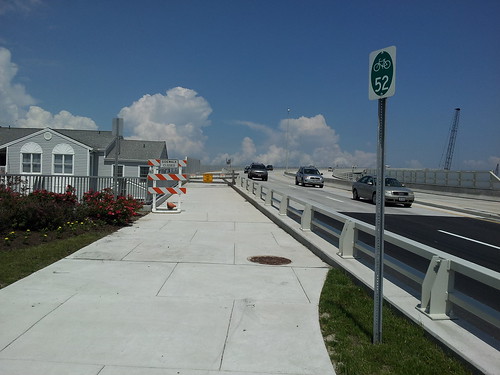 |
| Complete Street Success - Route 52 Causeway in Ocean City |
Monday, May 06, 2013
Public Workshop Looks At Connecting Trails and Complete Streets in Gloucester County.
The Association of New Jersey Environmental Commissions and the William Penn Foundation have teamed up to hold the Connecting Gloucester workshop on May 11th. The workshop looks at the successes of municipal plans as well as how local work in the County connects with the Circuit -Greater Philadelphia's regional trail network.
WORKSHOP PROGRAM
Saturday May 11th, 9AM - 12PM
Harrison Township Municipal Building
114 Bridgeton Pike, Mullica Hill, NJ
(Transit Directons)
The cost of admission is $10 for the general public ($5 for ANJEC members). To register contact ANJEC via this formatted email or call 973-539-7547.
Event Flyer
WORKSHOP PROGRAM
- The Basics of Local Bike/Ped/Trails Planning and Harrison Township Case Study
Bob Melvin, PP, AICP, Principal, Group Melvin Design - New Jersey DOT’s Local Bicycle/Pedestrian Planning Assistance Program
William Riviere, Principal Planner, NJDOT - Connecting The Circuit
Sarah Clark Stuart, Policy Director Bicycle Coalition of Greater Philadelphia - DVRPC’s Regional Trails Program for Multi-use Trails Project Implementation
Christopher Linn, AICP Manager, Office of Environmental Planning, DVRPC
Saturday May 11th, 9AM - 12PM
Harrison Township Municipal Building
114 Bridgeton Pike, Mullica Hill, NJ
(Transit Directons)
The cost of admission is $10 for the general public ($5 for ANJEC members). To register contact ANJEC via this formatted email or call 973-539-7547.
Event Flyer
 |
| Monroe Township Bike Path near Glassboro |
Monday, November 26, 2012
Restore the Shore Better than Before!
You have seen the disaster photos over and over, but what I noticed in these photos was that the most basic forms
of transportation - walking and biking were the only viable ways to get around in the hours immediately after the storm.
In the absence of subways, traffic signals and even gas stations, Bike Portland did an excellent job of documenting the surge of bicycle traffic in Lower
Manhattan and Brooklyn. On a lesser scale pictures from the barrier islands showed the
same thing. Roads were either destroyed or covered with sand and debris
that made car travel impossible.
Buried within the $30 billion dollar price tag are miles of damaged boardwalks and multi-use paths.Check out the shambles left over from the Sandy Hook Bikeway and the Henry Hudson Trail. The tourist packed boardwalks will be rebuilt very quickly (perhaps too quickly). But the lesser used off-road paths may be pushed way down the priority list and perhaps in the case of the frequently damaged Bayshore section of the Henry Hudson Trail,a discussion about a total redesign. It is going to take a concerted effort by bicycle and walking advocates to bring these trails back up to speed
The discussion of sustainable redevelopment of the coast is focused around the restoration of natural features to buffer the damage that robust coastal storms bring as well as implementing stricter building codes. But this rebuild is also an opportunity to create a more sustainable and safer transportation system as well.
Route 35 between Island Beach and Pt. Pleasant is a great example. In the 50's and 60's this road was expanded to create a four lane highway through some of the most densely built beach communities in the state. While there are wide shoulders, much of the road lacks sidewalks, crosswalks and even landscaping. To reform minded planners and landscape architects Route 35 looks like a blank slate.
View Larger Map
We can make this a complete street! Photoshop anyone?
The need to cross major arterials in shore communities is very strong. Accommodating all those beachgoers with beachfront parking would require huge and unsightly parking fields. So most renters and weekend visitors use the best ways available to get there - on two feet or two wheels (or sometimes 3 wheels). These roads are often the biggest barriers to get to the beach and can be especially frightening for groups with lots of gear and small children.
The rebuild of roads like Route 35 and Route 71 will put the NJ's complete streets policy to the test. County roads such as Long Beach Blvd are not subject to the State's policy, but the discussion to make all roads ravaged by Superstorm Sandy safer begins Today!
Buried within the $30 billion dollar price tag are miles of damaged boardwalks and multi-use paths.Check out the shambles left over from the Sandy Hook Bikeway and the Henry Hudson Trail. The tourist packed boardwalks will be rebuilt very quickly (perhaps too quickly). But the lesser used off-road paths may be pushed way down the priority list and perhaps in the case of the frequently damaged Bayshore section of the Henry Hudson Trail,a discussion about a total redesign. It is going to take a concerted effort by bicycle and walking advocates to bring these trails back up to speed
 |
| Multi-Use Path at Sandy Hook |
The discussion of sustainable redevelopment of the coast is focused around the restoration of natural features to buffer the damage that robust coastal storms bring as well as implementing stricter building codes. But this rebuild is also an opportunity to create a more sustainable and safer transportation system as well.
Route 35 between Island Beach and Pt. Pleasant is a great example. In the 50's and 60's this road was expanded to create a four lane highway through some of the most densely built beach communities in the state. While there are wide shoulders, much of the road lacks sidewalks, crosswalks and even landscaping. To reform minded planners and landscape architects Route 35 looks like a blank slate.
View Larger Map
We can make this a complete street! Photoshop anyone?
The need to cross major arterials in shore communities is very strong. Accommodating all those beachgoers with beachfront parking would require huge and unsightly parking fields. So most renters and weekend visitors use the best ways available to get there - on two feet or two wheels (or sometimes 3 wheels). These roads are often the biggest barriers to get to the beach and can be especially frightening for groups with lots of gear and small children.
The rebuild of roads like Route 35 and Route 71 will put the NJ's complete streets policy to the test. County roads such as Long Beach Blvd are not subject to the State's policy, but the discussion to make all roads ravaged by Superstorm Sandy safer begins Today!
Wednesday, October 17, 2012
Medford Township Passes A Complete Streets Policy
Medford Township has become the first municipality in Burlington County to pass a complete streets resolution. Congratulations Medford!
TOWNSHIP OF MEDFORD
October 16, 2012
RESOLUTION 132-2012
Establishing a Complete Streets Policy
WHEREAS, the Township of Medford
WHEREAS, the Township Council supports this “complete streets” initiative and desires to reinforce its commitment to creating a comprehensive, integrated, connected street and road network that safely accommodates all street and road users of all abilities for all trips; and
NOW, THEREFORE, BE IT RESOLVED by the Township Council of the Township of Medford that the Township hereby supports the “complete streets” initiative by making it Township policy that all public street and road projects, both new construction and reconstruction (excluding maintenance) undertaken by the Township of Medford shall be designed whenever feasible and subject to Council approval to do so in order to safely accommodate travel by pedestrians, bicyclists, public transit, and motorized vehicles and their passengers, with special priority given to pedestrian safety, subject to the following conditions:
A. Pedestrian and bicycle facilities shall not be required where they are prohibited by law.
B. Public transit facilities shall not be required on streets or roads not serving transit routes and the desirability of transit facilities will be determined on a project specific basis.
C. In any project, should the cost of pedestrian, bicycle, and/or public transit facilities cause an increase in project cost exceeding 5% as determined by engineering estimates, that would have to be funded with local tax dollars, then, and in that event, approval by Council shall be obtained for the same prior to bidding the project.
I hereby certify that the foregoing is a true copy of a Resolution adopted by the Township Council of the Township of Medford
Wednesday, September 26, 2012
Press Release - Newark to Launch Complete Streets Program
INITIATIVE WILL MAKE STREETS FRIENDLY FOR ALL USERS OF ALL ABILITIES
Program designed to create street corridors and intersections that will be safe
for pedestrians, motorists, bicyclists, seniors, children, and the mobility-challenged
Newark, NJ – September 25, 2012 – Mayor Cory A. Booker and Engineering Director Mehdi Mohammadish announced today that the City of Newark adopted a Municipal Council Resolution creating a “Complete Streets Policy.” This policy was adopted by the Municipal Council on September 6, 2012, is designed to create street corridors and intersections that will be safe for pedestrians, motorists, bicyclists, seniors, children, and the mobility-challenged.
The Complete Streets Policy will create a comprehensive, integrated, connected multi-modal network by facilitating connections to bicycling and walking in all of the City’s street and sidewalk projects.
“We have taken a holistic approach to making our streets and sidewalks safe and accessible for all of our residents and visitors, whether they walk, drive, or bicycle. Newark’s streets will be the safest and most welcoming in the entire nation,” Mayor Booker said.
“We have always emphasized the highest levels of accessibility and safety in our efforts to maintain and improve our streets and sidewalks. The Complete Streets program will provide us with a comprehensive plan to achieve those goals,” said Director Mohammadish.
“Complete Streets is defined as a means to provide safe access for all users by designing and operating a comprehensive, integrated, connected multi-modal network of transportation options,” said Manager of Traffic and Signals Jack Nata. “Newark is committed to creating street corridors and intersections that safely accommodate all users of all abilities.”
The Complete Streets program calls for the following:
Tuesday, August 14, 2012
Atlantic City Bicycle and Pedestrian Plan Open House Tonight
If you live, work or visit Atlantic City then you are welcome to attend and comment on the City's Bicycle and Pedestrian Plan at the open house tonight August 14th at the Atlantic City Convention Center/Train Station from 5 to 8PM in Room 314.
Atlantic City has one the highest bicycle/walk/transit commute mode shares in the State with a high pedestrian crash rate. Since 1980 drive up Casino development has dominated the landscape of the City and little was done to protect the safety of bicyclists and pedestrians. While some enhancements have been completed in "The Walk" shopping district, Michigan, Atlantic, Arctic and Baltic Avenues cut through the busy shopping districts as multi-lane roads which encourage high speeds. Right turn on red is also allowed at most of those intersections, further exacerbating a chaotic situation.
For bicycling there are two major proposals planned - 24 bike access on the non-commercial north end of the boardwalk along with a complimentary on street loop plus a proposed lane reduction of Atlantic Avenue with buffered bike lanes or cycle track added. What we will be looking for in the plan is a network of bike routes that will connect all the neighborhoods and the surrounding communities, such as improving access to the Brigantine Bridge.
Details and graphics from the meeting as well as instructions to comment on the plan will be posted on the Active Transportation for Atlantic City Facebook Page. AC's Bike and Ped plan is the first one in the State that is being completed after the Municipality has passed a complete streets resolution. Implementation of the plan is a litmus test to see if the City is ready to walk the walk towards complete streets.

Atlantic City Statistics:
Commute To Work
Transit - 27%
Walk - 16%
Bike - 2%
Vehicular Crashes 2011 - 2,307
Complete Streets Policy resolution passed on December 7, 2011
Atlantic City has one the highest bicycle/walk/transit commute mode shares in the State with a high pedestrian crash rate. Since 1980 drive up Casino development has dominated the landscape of the City and little was done to protect the safety of bicyclists and pedestrians. While some enhancements have been completed in "The Walk" shopping district, Michigan, Atlantic, Arctic and Baltic Avenues cut through the busy shopping districts as multi-lane roads which encourage high speeds. Right turn on red is also allowed at most of those intersections, further exacerbating a chaotic situation.
For bicycling there are two major proposals planned - 24 bike access on the non-commercial north end of the boardwalk along with a complimentary on street loop plus a proposed lane reduction of Atlantic Avenue with buffered bike lanes or cycle track added. What we will be looking for in the plan is a network of bike routes that will connect all the neighborhoods and the surrounding communities, such as improving access to the Brigantine Bridge.
Details and graphics from the meeting as well as instructions to comment on the plan will be posted on the Active Transportation for Atlantic City Facebook Page. AC's Bike and Ped plan is the first one in the State that is being completed after the Municipality has passed a complete streets resolution. Implementation of the plan is a litmus test to see if the City is ready to walk the walk towards complete streets.
Atlantic City Statistics:
Commute To Work
Transit - 27%
Walk - 16%
Bike - 2%
Vehicular Crashes 2011 - 2,307
Complete Streets Policy resolution passed on December 7, 2011
Wednesday, July 18, 2012
Morristown passes its own Complete Streets Policy
Our good friend, Kendra Arnold of Bike and Walk Morristown informed us just a few minutes ago that Morristown has passed its very own comprehensive Complete Streets Policy.
One of the most telling parts of a government entity's commitment to it's Complete Policy is in the Exceptions. While the policy is otherwise very good, the exceptions are a little vague and could be manipulated to scrap otherwise worthy / needed complete street projects. "d" is particularly concerning as there is no definition of "disproportionate cost." The standard is that bike/ped improvements not exceed 15% of the total project cost. The vague exceptions of concern are below.
Good job Morristown!
One of the most telling parts of a government entity's commitment to it's Complete Policy is in the Exceptions. While the policy is otherwise very good, the exceptions are a little vague and could be manipulated to scrap otherwise worthy / needed complete street projects. "d" is particularly concerning as there is no definition of "disproportionate cost." The standard is that bike/ped improvements not exceed 15% of the total project cost. The vague exceptions of concern are below.
c) Detrimental environmental or social impacts outweigh the need for these accommodations.Putting that aside another mutual friend, Gerald points out that the policy places emphasis on planning for future bicyclists and pedestrians. A good cool point. Also the checklists are pretty neat and make it simple for implementers in the future to follow the policy.
d) Cost of accommodations is excessively disproportionate to cost of project.
e) The safety or timing of a project is compromised by the inclusion of Complete Streets.
Good job Morristown!
Thursday, June 16, 2011
3 Complete Streets seminars coming in July for locals
NJ Future just reported about how Jersey City and Ridgewood both passed Complete Streets policies recently. Great news but NJ Future notes that this brings the total number of municipalities with Complete Streets policies up to 12 and counties (Monmouth) up to 1. When you realize that New Jersey has 566 municipalities and 21 counties, you begin to see that there is a long way to go.
So step in Sustainable Jersey, supported by Shaping NJ (and a host of other organizations), which has scheduled three workshops on Complete Streets for local activists interested in pursuing the policy in their towns. Each workshop will highlight basic policy principles, potential resources and local case studies. The workshops will be held on:
So make sure you and/or one or more of your local town officials try to attend one of these seminars and get your own Complete Streets policy in place.
So step in Sustainable Jersey, supported by Shaping NJ (and a host of other organizations), which has scheduled three workshops on Complete Streets for local activists interested in pursuing the policy in their towns. Each workshop will highlight basic policy principles, potential resources and local case studies. The workshops will be held on:
- July 14 at Stockton College from 1 to 3:30 p.m. (register)
- July 19 at the West Windsor Municipal Building from 9:30 a.m. to noon (register)
- July 21 at the Rahway Public Library from 6 to 8 p.m. (register)
So make sure you and/or one or more of your local town officials try to attend one of these seminars and get your own Complete Streets policy in place.
Subscribe to:
Posts (Atom)