This morning on the last day of school A first grader riding his bike to the Magowan Elementary School in Edgewater Park, Burlington County suffered from minor injuries when he was struck by a car on Cherrix St shortly after 8:30AM just a couple of hundred feet from the school entrance.
I have reported on lots of bicycle crashes but this was different for me. 10 minutes after I put my 5 year old on the school bus I saw a rescue squad ambulance racing towards the school, which sent a fearful pang that a worried parent sometimes feels. But I had to bike to the school anyway to drop off some paperwork which eased that feeling.
But then I turned left towards the school I found out why the ambulance blew by. I saw a school bus a Chevy Suburban, several patrol cars and a gathering of people but it was the two bikes on the ground that told the story, a child on a bike was struck.
That bad feeling came back.
A raised crosswalk on Cherrix Street in front of Magowan the crash occurred at another raised crosswalk just a few feet behind from where this picture was taken.
The crash took place at a raised crosswalk, installed several years ago as part of the Burlington County Safe Routes to School initiative. As I rode by the scene I overheard the driver of a large black Chevy Suburban talking to police state - "I didn't see him". Not knowing the circumstances of the crash, I can only speculate that traffic calming may have prevented a much more serious crash. If that's the case then it's money well spent
Perhaps I am most proud of the way that the Principal Betsy Miles explained the story in a memo sent home - "Although this incident was an accident, it certainly shines a bright light on bike safety...On the back of this letter are some basic tips to start your conversation...Have a fun safe summer."
I really expected some negative results, bike to school crashes in small school districts have led to bike bans in places such as Collingswood. But Ms. Miles and her staff should be commended for generating a reasonable response and for seizing a teaching moment. Hopefully the school board will display the same clarity and look at programs to make bicycling to school safer without resorting to a ban on riding bikes to school.
The first public meeting for the Maywood, NJ Bicycle/Pedestrian Study will be held next Thursday, June 17, from 3:00pm to 7:00pm. You do not need to attend for the entire four (4) hour session. Simply stop by anytime for as long as you like.
You have been to these places on vacation, you step into a crosswalk and traffic going both ways stop. In many places in the country that is the norm but it seems that the urban Northeast Corridor never got the memo. There are plenty of idiot drivers in Charlotte and Boise but most drivers in those cities know how to react to a pedestrian in a crosswalk.
In New Jersey where turning right on red is a birthright the "Stop For Pedestrians In The Crosswalk" appears to have puzzled a generation of suburban drivers trained to own the road and nowhere is this more evident than densely packed shore towns. The streets which lie on a modified urban grid are teeming with pedestrians who cannot park at the beach. Pedestrians and motorists alike seem to have little experience coexisting.
Inevitably lack of understanding generates backlash, the Atlantic City Press reports that Long Beach Township businessman Dick Jeffries has started a petition to repeal the stop for pedestrians law with the endorsement of Mayor Joseph Mancini. The local State Representatives are in agreement including Assemblywomen Gove, my 9th Grade Social Studies Teacher.
Jeffries quotes in the article totally reflect his windshield view of traffic safety:
"People don’t know what to do because the law is so unclear. Everyone is so frightened by this thing with these big signs they put up. I mean, what is it? A $200 fine and two points on your license?”
Mancini's perspective is even more myopic -
Mancini said it’s horrific that the law was enacted because of a 2009 fatal accident in Ocean City, when 21-year-old Casey Feldman, of Springfield, Pa., was killed crossing an intersection in July.
“It’s only going to work on roads with two lanes, not a five-lane highway,” Mancini said.
With New Jersey ranking near the top of pedestrian fatalities it's hard to believe that smart accomplished people are engaging in this counter intuitive argument. That allowing motorists to drive with less care is safer.
In the Book "Traffic" Author Tom Vanderbilt discusses an point that is even more counter intuitive but correct - In Chapter 7 he writes that in 1967 Sweden switched driving from the left side to the right side of the road overnight and the immediate result was that road traffic crashes declined which of course was totally unexpected. Vanderbilt theorizes that the roads felt less safe and drivers and pedestrians alike reacted with more caution. Jeffries fearful reaction is exactly the message that needs to be conveyed-be afraid it may save someone's life.
The Delaware River Heritage Trail is a planned trail network that spans the upper tidal section of both sides the Delaware River from the Tacony Palmyra Bridge between Philadelphia and Palmyra to the Calhoun St in Trenton which connects Trenton NJ and Morrisville, PA.
On the Pennsylvania side Planning for the trail is underway and well funded as the trail alignment there will be the same as the Pennsylvania section of the East Coast Greenway.
The New Jersey side of the trail lacks such grass roots sponsorship. Implementation of the trail rests on several agencies and governments, divided between the Delaware and Raritan Canal Commission, Mercer County Parks and Burlington County Traffic Engineering and Burlington County Open Space Planning.
Three small sections of the trail are complete. The Delaware and Raritan Canal from Lalor St to Crosswicks Creek across from Bordentown, The Burlington Waterfront Promenade with a path extension to the Burlington YMCA and Burlington South Train Station and along the RiverLINE alignment in Riverton and Palmyra. Additionally two disconnected sections between Burlington and Bordentown are in final design and may be ready for construction within the next year.
But there is much more to do, with more than a dozen communities involved it will be a heavy lift to keep the momentum going to make sure that this trail is done in the next 5 years. The Bicycle Coalition of Greater Philadelphia has started a Friends of the Delaware River Trail Facebook Group. The group will hopefully be a catalyst for a citizens based movement to assure that the trail remains a priority and fully funded for quick implementation. Trail maintenance and events are some of the ways this group can support the effort. If you are interested in promoting the regional trail project as well as keeping up with trail update then I would ask you to join this Facebook Group.
NJDOT recently released its environmental assessment of the reconstruction of the Manahawkin Bay Bridge which carries NJ Route 72 over to Long Beach Island. The Manahawkin Bay Bridge is actually a series of four bridges and three islands than span 2 miles from the mainland to LBI. Today there are absolutely no accommodations for pedestrians nor bicycles over the current bridges. The entire length of this bridge and its approaches on either end are considered to be structurally deficient and functionally obsolete which means they need either major repair or replacement. As such NJDOT is proposing a complete overhaul and rebuilding of this span that will even include the construction of completely new bridges to the south of the current structure for a portion of the crossing.
Unfortunately, while still a preliminary proposal, the suggested bicycle and pedestrian improvements seem grossly inadequate in a age of enlightened NJDOT with a Complete Streets Policy. While from a strictly engineering perspective the preliminary proposal may seem minimally sufficient at best, the functional reality is likely to be much less.
The preliminary proposal calls for pedestrians to be accommodated with a 6 foot wide sidewalk on the north side of the bridge (west bound) that is interrupted on Bonnet Island (the large center island), where pedestrians would then walk on what is already today "Old Rt 72". No sidewalk would be provided on this stretch. Under several of the bridge foundations, the sidewalk would continue under the bridges to provide access to the south of the roadway. For a map showing all the details of the proposed pedestrian access plan see this rendering.
A six foot wide sidewalk is rather narrow for a bridge the spans 2 miles with its longest bridge section a half (0.5) mile across. Also, the proposal does not call for the sidewalk to be separated from the shoulder of the highway by any barrier or divider. It would seem that this proposal meets the bare minimum of what is considered acceptable pedestrian access. The very nature of the proposed pedestrian facilities are far from ideal and seems to provide the most hostile pedestrian environment possible while still providing pedestrian access. Also, the proposed accommodations for bicyclists are also far from ideal (more below). As such cyclists will likely ride on the sidewalk, which at only six feet, is an inadequate width to accommodate both bicyclists and pedestrians. Finally, it does not appear that any provision has been made to allow pedestrians to cross to the southern side of Cedar Bonnet Island which has residences on both sides of the highway.
Bicyclists are proposed to be accommodated by use of the roadway shoulder and bike lanes. On the eastern side of the project NJDOT proposes to refurbish the existing two eastern most bridges where bicyclists would be accommodated by two 5 foot wide bicycle lanes; one in each direction. In the western portion of the project over the main part of the bay NJDOT has accepted the proposal to build two parallel bridges just to south of the existing bridge and then to rehabilitate the old bridge after the new one is completed. Here bicyclists would be accommodated with a 13 foot wide shoulder.
Cross section diagram of the proposed final build of the western two bay bridges.
The bridge to the right represents the new span: Source NJDOT Cross section diagram of the proposed final build of the eastern two trestle bridges. Note the five foot wide bicycle lanes on each side of the roadway. Source NJDOT
While 13 foot shoulders on the western two bridges is more than adequate for experienced adult cyclists, this is still not a desirable place to ride for novice cyclist nor for children particularly when motor-vehicle traffic is traveling at and in excess of the posted 55mph speed limit. On the eastern two bridges the 5 foot bicycle lanes are grossly inadequate when motor vehicle traffic will be passing within 5 feet or less of a bicyclists left shoulder, again at or in excess of the posted 55mph speed.
Finally, the proposed improvements to both the mainland and LBI approaches to the bridge seem to show little concern for how bicyclists are to traverse these critical sections (see pdf renderings 1 & 2). On both sides the shoulders fade to the curb-line to accommodate high speed exit and on-ramps. Of special concern are the proposed improvements on the mainland. In particular, the eastbound mainland approach for cyclist would require riding in the shoulder for a stretch, crossing a high-speed off-ramp, then riding in a high-speed on-ramp for an undisclosed extended distance. Such lack of consideration for cyclists in these sections is intolerable in a day when well engineered bicycle lanes have been accepted practice for well over a decade. Also, the preliminary renderings for the mainland approach show no pedestrian facilities beyond the sidewalk over the bridge. There are no other sidewalks or crosswalks currently proposed anywhere on the mainland side of the project.
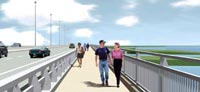
A rendering of the planned Rt 52 multiuse walkway/bike path. Source NJDOT
On a bridge of this length (2 miles) persons on foot or on a bicycle persons on foot will required an extended period of time to cross. The current proposal provides little for these persons to escape the constant unnerving presence of high-speed, 55mph traffic. To expect a pedestrian or bicyclist to cross a two mile bridge with little refuge and in places absolute minimal refuge (5 foot bicycle lane) from traffic is not reasonable. Such a task is barely tolerable by the standards of adventurous adults and is without question something that few parents would want to do with children. It is also difficult accept that better bicycle and pedestrian facilities cannot be accommodated when on the western two bridges, automobile traffic will be accommodated with shoulders, (shoulders!) of at least 12 feet in width on both sides for a total of four shoulder lanes totaling 50 feet!
For the reasons I cite above it is my opinion, that while preliminary, the proposed bicycle and pedestrian facilities for the Route 72 Manahawkin Bay Bridge are completely unacceptable, without compromise and should be revisited with an eye to providing bicycle and pedestrian access that most adults would feel is safe for middle-school aged children to traverse. This is particularly important on this project since it will provided the only means by which persons can access Long Beach Island by land. To compensate for the expected discomfort and likely dangers bicyclists and pedestrians will undoubted encounter using the currently proposed improved Route 72 Manahawkin Bay Bridge, bicyclists and pedestrians should be accommodated by a separated facility of at least 10 feet in width like that already being constructed on Route 52.
To help prove my point I would also suggest the NJDOT produce a study looking at the bicycle and pedestrian level of service provided by these preliminary proposals. These results should be then compared to other build proposals for bicycle and pedestrian accommodations that could be feasible within the footprint of the proposed bridge structure footprints, like a separated and protected multi-use lane on the north side of the bridge. I am confident that such an analysis will reveal that much better bicycle and pedestrian alternatives are feasible that will not effect the budget of this proposed project by any reasonable significance.
Finally, it is understood that these are very preliminary proposals and that not all details are finalized. More detail of how exactly pedestrians and cyclists are to be accommodated are likely to come. However, it should be noted that these preliminary plans already show in great detail exactly how all motor-vehicle lanes are expected to be constructed. The proposal also calls for a final constructed project that goes well above and beyond even any future projected motor-vehicle volume needs. There really isn't anything wrong with that until one compares the cursory if not curt nature by which bicycle and pedestrian need are addressed. It does not leave one feeling confident that those needs will be addressed without constant, vigilant monitoring by bicycle and pedestrian advocacy groups. Imagine if motorists felt as compelled to be as attentive, to prevent dangerous roads being built for them.
Plan for south end bike path would run along West Ave., or railroad bed
Written by ANN RICHARDSON
Thursday, 15 April 2010 20:01
OCEAN CITY – A group of bicyclists behind the Haven Avenue bike path will go to the public next week with a proposal to extend that bike path from 35th Street to 51st Street either on a reconfigured West Avenue or the old Seashore Line railroad bed in the marshes. The proposal is part of a plan to create an island-wide bike path that would allow bicyclists to ride from Corson’s Inlet on the southern end of the island to the Ocean City-Longport Bridge in the north, head out over the multi-use pathway to Somers Point on the new Route 52 causeway or ride downtown and to the Boardwalk.
Tom Heist IV, who leads the group of cycling enthusiasts, said he knows aspects of the plan will be controversial, especially the potential use of the railroad bed parallel to West Avenue. He said the public meeting is scheduled to get public input on the matter.
“There is no hidden agenda, there is no back door deal on this,” Heist said. “We are vetting this concept in a civilized way. We are saying to the public, would you rather see West Avenue reconfigured or would you rather we expend the energy necessary to rebuild that railroad bed? There is a lot of support for that option so we are going to explore it.”
The group plans to meet at the Ocean City Free Public Library on Monday, April 19 from 6:30 to 8:30 p.m. to discuss the 35th Street to 51st Street project.
The Haven Avenue bike path runs from Ninth to 35th streets. Heist said it is critical that the existing “spine” be continued on to 51st Street.
“We really need to do 35th Street to 51st Street,” he said. “It’s a 16-block critical gap. West Avenue as it is now configured is not a safe road to ride bikes.”
Heist said four lanes of traffic on West Avenue are currently bordered on each side by four-foot bike lanes, which is dangerous because drivers open their car doors into the lanes. (WBJ Note: the minimum standard for bike lanes next to parking is at least 5 feet)
“That’s the most dangerous thing for a bike, the car door,” he said. “It’s much better to have the car door open on the passenger side; there is much less a chance of hitting a biker on that side.” Cape May County officials are willing to re-stripe West Avenue so that both four-foot bike lanes are together on the west, or bay side, of West Avenue, Heist said. The bike lane would be near the curb to avoid driver’s side doors and the parked cars would serve as a barrier between traffic and cyclists.
“Bikes could safely ride by the curb,” Heist said. “We have evaluated the safest places to put bike lanes, and it is in a separated lane, not in traffic. The county is prepared to re-stripe it so that is an option. It would provide an added level of safety.”
Heist said a number of people have approached his group about the old railroad bed in the marshes and whether it could be utilized. The option will be vetted at the public meeting, he said. The question is whether to restripe West Avenue or use the railroad bed, said Heist.
“We are presenting our ideas to the public,” he said. “We have invited lots of public officials; we want to see the community come out as well. We want to get the pulse. We want a civilized public discussion. We want to get everyone out riding bikes, from small children and older children who want to follow their parents on bikes to our senior citizens who might be less stable as they get older. Everyone has a right to be able to safely enjoy bike riding in Ocean City.”
There are also plans to connect the Gardens section to the Haven Avenue bike path and the multi-use pathway coming over the new Route 52 Causeway. Bike paths could run from the bridge to the Boardwalk, said Heist.
Heist said his group has received an engineering report by the firm Orth-Rodgers concerning a plan to connect the 10-foot wide multi-use pathway from the Route 52 Causeway with both the bike path on Haven Avenue beginning at Ninth Street and the Boardwalk.
“It just arrived, it’s not ready to be presented as yet,” he said. “We are going to present the recommendations with a transportation subcommittee for review. It can’t be rushed. We do not want to present bits and pieces, it must be presented professionally.”
The study looked at adding a bike path to Sixth, Seventh, Eighth or 10th streets by taking out parking on one side of the roadway and continuing two lanes of traffic flowing east and west. The study also looked at the possibility of reducing Ninth Street from four lanes to two lanes from West Avenue to the ocean, with a bike path on the south side of the road.
“We need a safe way to allow people to pedal off of Ninth Street,” Heist said. “We want to connect the Boardwalk through the downtown, to allow people coming over on their bikes from Linwood to stop and shop.”
“We want to provide for bicyclists the safest route possible,” he added. “Do we just continue to put bikes out in the street and say good luck? We can’t continue to do this.”
Heist said there is pent-up demand to ride bikes in town but the existing infrastructure cannot support it. People ride for recreation, to get to summer jobs, or, like his mother, to go shopping, Heist said.
“She’s an adamant bike rider,” said Heist. “She scares me to death. I worry, the streets are not designed for bikes. I’m not willing to take this risk. It’s unfair to ask us to put our lives in jeopardy.”
Heist said members of his group travel around the country exploring bicycle-friendly communities, discovering what’s new and exciting, what’s working and how it could be incorporated in Ocean City. They’ve imported concepts like traffic calming devices in the form of artwork in busy intersections to remind motorists to slow down and watch for cyclists. The group presented the idea for a street mural to the Community Art Project last year and a mural at 20th Street and Haven Avenue intersection was the result.
Ann Richardson can be e-mailed at annrichardson@catamaranmedia.com or you can comment on this story by calling 624-8900, ext. 223.
With the sell-out success of the first New Jersey Bicycle Summit, the second event is sure to be even better. And being more centrally located in Trenton, it is very likely that this Summit will attract more representatives from bicycling organizations in the southern part of the state.