I had the great pleasure and honor studying under Prof. John Pucher at the Bloustein School of Planning and Public Policy at Rutgers University. Dr. Pucher or as he calls himself "Car-Free John" is one of the leading researchers when it comes to analyzing the effects of proactive bicycle and pedestrian policies with that of public health, transportation expenditures, transportation mode shares etc. usually comparing the policies of one country to another.
The story begins by following Dr. Pucher's bike commute and then profiles a Summit family that gets around by bicycle. The final segment focuses the popularity of bicycling and the poor road conditions in urban New Brunswick. Overall a good snapshot of bicycling in New Jersey. Now all we need is to convince our elected officials to muster up the political will to make bicycling a real transportation option.
Wednesday, September 29, 2010
Monday, September 27, 2010
Focus On - Princeton
As promised, the next installment in WalkBikeJersey’s “Focus On” special is of Princeton. To be more specific we will be focusing on Princeton Borough and in particular one neighborhood in close proximity to downtown.
The reason why I choose Princeton Borough for the second installment was due to some of the innovative and rare traffic calming features (at least in New Jersey) found in the neighborhood just to the southwest of downtown. This neighborhood is bounded by Stockton Street and Bayard Lane (Route 206), and by Great and Westcott Roads and contains some of the finest homes in all of New Jersey, which undoubtedly means that it also has some of its most wealthy residents. While there are only residential land uses in this neighborhood, nearly all the streets connect through to the other main thoroughfares leading in and out of this side of town. During rush hour, traffic backs up rather badly at the intersection where Route 206 meets the terminus of Route 27 (Nassau St). As such this neighborhood is subject to drivers looking to circumvent this congested intersection, particularly those traveling through town on Route 206.
View Princeton - Traffic Calmed Neigborhood in a larger map
To mitigate drivers speeding through the neighborhood about ten years ago Princeton Borough installed a number of advanced traffic calming devices. You won’t find a single primitive speedbump here! Instead borough officials used a coordinated ensemble of different devices such as mid-block neck-downs, mini traffic circles and low, cobbled traffic islands. Through connections on one or two streets have also been closed to motor vehicle traffic but the sidewalks have remained to allow bicyclists and pedestrians continued, convenient access. Overall, the application of all these traffic devices was refreshingly sophisticated and novel which is appropriate for a community with one of the greatest brain trusts in Western Civilization.
The most common traffic calming device used in the neighborhood were traffic islands located in the center of the streets, usually just in front or behind an intersection depending on ones approach. The islands are made with low lying Belgian block that is only an inch or two higher than the asphalt at the margins but then rises a few inches more near the center. The design details of this feature causes enough discomfort to discourage drivers of passenger cars from riding over them, therefore requiring them to slow down to avoid the islands, but will not cause any damage to a car if they do. However these traffic islands are easily driven over by large trucks or emergency vehicles like fire engines, on the rare occasions these vehicles must traverse these streets to reach a local destination.
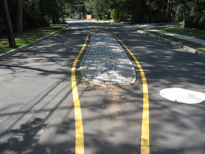 This photo demonstrates some of the construction details common
to all of the traffic calming islands in this neighborhood.
The first set of Belgian blocks is about an inch above the grade of the asphalt
and the islands are crowned at the center about three or four inches more.
Neck-downs or a narrowing of the street on both sides are also used in several key locations. From what I observed, these neck-downs move the curb in towards the centerline of the roadway less than the width of a parallel-parked automobile but they still leave enough room for two oncoming cars to pass one another inside the device. In one location a neck-down not only slows traffic but also provides room for a sidewalk while eliminating to need to take down a large specimen tree that happened to be close to the street. Very clever!
 This neck-down narrows the street about two feet on either side.
It would appear that the neck-down provided enough space to place a sidewalk on the
right side of the street without calling for the removal of the large trees in the background.
Finally, the most unique traffic calming device were mini traffic circles used at two, four-way intersection. While routinely used in the Pacific Northwest, particularly in Portland, this is the only application of this device that I have observed in New Jersey. Mini traffic circles are placed in the center of a four-way intersection usually without modifying the dimensions of the curbline at the corners. They are about eight to twelve feet in diameter and are typically landscaped with ornamental vegetation, often including a tree as was done at the two intersections in Princeton. Stop signs are replaced with yield signs and drivers are expected to yield to traffic already in the mini-circle, as is typically the custom, and proceed around the circle to the right in a counterclockwise direction.
 This mini-circle is located at the intersection of Lafayette Road and Cleveland Lane.
Notice the various signage, crosswalks and the mini-circle itself with landscaping including tree.
Also notice how the landscaping could block a drivers view of pedestrians in the far crosswalk.
The original idea behind this device was to force drivers to slow down and drive with caution through the intersection, particularly those who are driving straight through the intersection and who may not have had a stop sign prior to the installation of the mini-circle. On the flip side, replacing stops signs with yield signs after installation of the mini-circle also allows for freer movement of traffic, eliminating unnecessary (and energy wasting) complete stops and replacing them with slow, cautious yields. Being able to cautiously and safely roll through an intersection can be especially beneficial to cyclists who like to maintain their hard earned momentum. Also, the additional greenspace and landscaping does add extra beauty to the neighborhood and at around 10 feet in diameter, the circle does provide enough room to plant large tree species which have the potential to provide cooling shade if allowed to grow to maturity.
Unfortunately the use of mini-circles has raised concerns about their effectiveness. Some professionals have questioned whether they are large enough to have a real traffic calming effect, particularly for traffic traveling straight through the intersection. Others question whether American drivers are knowledgeable enough about the custom of yielding to traffic in the circle and signaling at the point of exiting. I personally also have concerns about the circle and the landscaping in it blocking a driver’s view of pedestrians crossing on the opposite side of the intersection (I nearly had a bad incident with a pedestrian as I was driving through a slightly larger roundabout in Germany. There it is common to place a tall mound of landscaped earth in the circle center, which in turn blocked my view of the pedestrian on the opposite side of the intersection. The near miss left me shaken.).
When I was taking pictures of the mini-circles I happened to strike-up a conversation with a man who is a local resident. He told me that he thought that the mini-circles were a bad idea since drivers don’t seem to know how to behave driving though them. According to his observations, it seemed that the drivers essentially ignore the yield signs and simply barge straight into the circle regardless of any other traffic that may be present and often doing so at speed. He said that he felt that the intersection was much safer when it was controlled by stop signs on all four corners. This gentleman’s personal observation seemed to reflect the concerns brought up by others regarding mini-circles.
Maybe some further refinements are required to make mini-circles more effective. Augment the mini-circles with the cobbled traffic islands leading up to and behind the intersections to help guide and slow motorists. If that is not enough maybe the inclusion of a speedhump on the approach to the intersection might bring vehicle speeds into compliance with what is intended for the mini-circle.
Beyond this one neighborhood, Princeton Borough and much of the immediate surrounding township is a walking and a relative cycling paradise. These didn’t just happen overnight. Like the all great walking and biking cities in Europe, Princeton has been working for many decades to provide accommodations for pedestrians and cyclists. Other facilities and innovations exist throughout the community and continue to be installed with just about every roadway improvement project. While the local governments may not have formal “Complete Streets” policies (they could now, I don’t know), it is clear that the spirit of such policy has long been in place. This and a long-standing policy of enforcing a pedestrian’s right-of-way in a crosswalk (well before it was sexy), makes Princeton one of New Jersey’s the leading bicycle and pedestrian friendly communities.
 This pedestrian refuge island, located at the intersection of Mercer and Nassau Streets,
is being constructed as part of a routine roadway rehabilitation project.
The prior crossing was very long and would leave pedestrians exposed to traffic
for a great deal of time as they crossed, even more so for elderly pedestrians.
The large paved area also allowed drivers to make turns at high speed.
The refuge island provides pedestrians literal refuge from traffic,
a place to rest which is critical for those who require more time to cross and
a prevents drivers from taking the turn at high speeds since they must now negotiate
driving around the island.
The reason why I choose Princeton Borough for the second installment was due to some of the innovative and rare traffic calming features (at least in New Jersey) found in the neighborhood just to the southwest of downtown. This neighborhood is bounded by Stockton Street and Bayard Lane (Route 206), and by Great and Westcott Roads and contains some of the finest homes in all of New Jersey, which undoubtedly means that it also has some of its most wealthy residents. While there are only residential land uses in this neighborhood, nearly all the streets connect through to the other main thoroughfares leading in and out of this side of town. During rush hour, traffic backs up rather badly at the intersection where Route 206 meets the terminus of Route 27 (Nassau St). As such this neighborhood is subject to drivers looking to circumvent this congested intersection, particularly those traveling through town on Route 206.
View Princeton - Traffic Calmed Neigborhood in a larger map
To mitigate drivers speeding through the neighborhood about ten years ago Princeton Borough installed a number of advanced traffic calming devices. You won’t find a single primitive speedbump here! Instead borough officials used a coordinated ensemble of different devices such as mid-block neck-downs, mini traffic circles and low, cobbled traffic islands. Through connections on one or two streets have also been closed to motor vehicle traffic but the sidewalks have remained to allow bicyclists and pedestrians continued, convenient access. Overall, the application of all these traffic devices was refreshingly sophisticated and novel which is appropriate for a community with one of the greatest brain trusts in Western Civilization.
The most common traffic calming device used in the neighborhood were traffic islands located in the center of the streets, usually just in front or behind an intersection depending on ones approach. The islands are made with low lying Belgian block that is only an inch or two higher than the asphalt at the margins but then rises a few inches more near the center. The design details of this feature causes enough discomfort to discourage drivers of passenger cars from riding over them, therefore requiring them to slow down to avoid the islands, but will not cause any damage to a car if they do. However these traffic islands are easily driven over by large trucks or emergency vehicles like fire engines, on the rare occasions these vehicles must traverse these streets to reach a local destination.
 This photo demonstrates some of the construction details common
to all of the traffic calming islands in this neighborhood.
The first set of Belgian blocks is about an inch above the grade of the asphalt
and the islands are crowned at the center about three or four inches more.
 This neck-down narrows the street about two feet on either side.
It would appear that the neck-down provided enough space to place a sidewalk on the
right side of the street without calling for the removal of the large trees in the background.
 This mini-circle is located at the intersection of Lafayette Road and Cleveland Lane.
Notice the various signage, crosswalks and the mini-circle itself with landscaping including tree.
Also notice how the landscaping could block a drivers view of pedestrians in the far crosswalk.
Unfortunately the use of mini-circles has raised concerns about their effectiveness. Some professionals have questioned whether they are large enough to have a real traffic calming effect, particularly for traffic traveling straight through the intersection. Others question whether American drivers are knowledgeable enough about the custom of yielding to traffic in the circle and signaling at the point of exiting. I personally also have concerns about the circle and the landscaping in it blocking a driver’s view of pedestrians crossing on the opposite side of the intersection (I nearly had a bad incident with a pedestrian as I was driving through a slightly larger roundabout in Germany. There it is common to place a tall mound of landscaped earth in the circle center, which in turn blocked my view of the pedestrian on the opposite side of the intersection. The near miss left me shaken.).
When I was taking pictures of the mini-circles I happened to strike-up a conversation with a man who is a local resident. He told me that he thought that the mini-circles were a bad idea since drivers don’t seem to know how to behave driving though them. According to his observations, it seemed that the drivers essentially ignore the yield signs and simply barge straight into the circle regardless of any other traffic that may be present and often doing so at speed. He said that he felt that the intersection was much safer when it was controlled by stop signs on all four corners. This gentleman’s personal observation seemed to reflect the concerns brought up by others regarding mini-circles.
Maybe some further refinements are required to make mini-circles more effective. Augment the mini-circles with the cobbled traffic islands leading up to and behind the intersections to help guide and slow motorists. If that is not enough maybe the inclusion of a speedhump on the approach to the intersection might bring vehicle speeds into compliance with what is intended for the mini-circle.
Beyond this one neighborhood, Princeton Borough and much of the immediate surrounding township is a walking and a relative cycling paradise. These didn’t just happen overnight. Like the all great walking and biking cities in Europe, Princeton has been working for many decades to provide accommodations for pedestrians and cyclists. Other facilities and innovations exist throughout the community and continue to be installed with just about every roadway improvement project. While the local governments may not have formal “Complete Streets” policies (they could now, I don’t know), it is clear that the spirit of such policy has long been in place. This and a long-standing policy of enforcing a pedestrian’s right-of-way in a crosswalk (well before it was sexy), makes Princeton one of New Jersey’s the leading bicycle and pedestrian friendly communities.
 This pedestrian refuge island, located at the intersection of Mercer and Nassau Streets,
is being constructed as part of a routine roadway rehabilitation project.
The prior crossing was very long and would leave pedestrians exposed to traffic
for a great deal of time as they crossed, even more so for elderly pedestrians.
The large paved area also allowed drivers to make turns at high speed.
The refuge island provides pedestrians literal refuge from traffic,
a place to rest which is critical for those who require more time to cross and
a prevents drivers from taking the turn at high speeds since they must now negotiate
driving around the island.
Wednesday, September 22, 2010
AAA Pushes to Cut Bike & Ped Funding. Speak Up Now!
The below message comes from the good people at the Rails-to-Trails Conservancy via our friends at the Bicycle Coalition of Greater Philadelphia. You should also know that the impetus behind this push to cut bike/ped planning is coming from the AAA Mid-Atlantic Offices which has an unfortunate history of opposing spending on bike/ped projects.
The American Automobile Association (AAA) wants Congress to cut long-standing programs that support trails, biking and walking in order to divert those funds to the highway system. (Read the background.)
These programs have played a major role in the development of more than 19,000 miles of rail-trail across the country, most likely including your favorite local trail. These trails and other walking and bicycling facilities allow individuals across the country to enjoy the outdoors and safely and easily travel without a car for many short trips—while saving money and gas, and getting exercise in the process.
AAA has forgotten that bicyclists and trail lovers drive, support AAA, pay gas taxes and want balanced transportation systems that provide the choice to get around in a variety of ways.
Help us help them remember! Sign the Petition
Petition sponsored by the Rails to Trails ConservancyRegister now for the NJ Complete Streets Summit!
The below message comes from Peter Bilton and the other good folks working hard at the Alan M. Voorhees Transportation Center at Rutgers University. This event is geared toward municipal and county officials so make sure local representatives know about it and get them to attend!
You should also know that Michael Ronkin, the keynote speaker, is with little doubt one of the leading experts in the field of Complete Streets, and bicycle and pedestrian planning and accommodation. Don't miss out on an opportunity to here one of the best in the world speak on this topic... and for free, no less!
Register now for the NJ Complete Streets Summit! (Or go to http://tinyurl.com/cssummit.) This is a free event.
NJ Complete Streets Summit
Friday, October 22, 2010
9:00 AM - 4:00 PM (Registration begins at 8:30 AM)
Rutgers Student Center
126 College Ave.
New Brunswick, NJ
The New Jersey Department of Transportation and the Voorhees Transportation Center, with funding from the Federal Highway Administration, are pleased to announce the NJ Complete Streets Summit, cosponsored by the NJ Chapter of the American Planning Association and the Metropolitan Section of the Institute of Transportation Engineers.
The Department of Transportation recently adopted a Complete Streets Policy, and would like to spread the word about this program, encouraging more counties and municipalities to adopt their own policies. The summit will educate engineers, planners, and elected officials about Complete Streets, its benefits and costs, and how to overcome barriers to implementing a Complete Streets policy. Topics will include an introduction to Complete Streets, policies and supporting processes, design and planning, cost and funding, and liability.
Michael Ronkin, an internationally-recognized consultant and speaker on innovative, practical street design, will be the keynote speaker. Assemblywoman Grace Spencer (invited) and NJDOT Commissioner James Simpson will give welcoming remarks.
Complete Streets are designed and operated to enable safe access for all users - pedestrians, bicyclists, motorists and transit riders of all ages and abilities. Instituting a complete streets policy ensures that agencies routinely design and maintain the entire right of way to enable safe access for anyone who may use it. Having a Complete Streets policy can benefit a community in many ways, including making their grant applications for state funding more competitive. A Complete Streets program is also eligible for points toward Sustainable Jersey certification and can help a municipality meet its obligations under the Americans with Disabilities Act.
Register here for this exciting Summit by October 8th! The event is free and space is limited. AICP and ITE credits are pending.
For more information, please see the attached flyer. You can also contact us at bikeped@rci.rutgers.edu or (732) 932-6812 ext. 586.
Hope to see you there,
Peter Bilton
Alan M. Voorhees Transportation Center
Rutgers, The State University of New Jersey
Monday, September 20, 2010
Biergarten Ride a Great Success
Google "Bike There" Directions Live Up to the Hype
Old New Jersey Suburbs Prove VERY Bikeable
This past Friday I had the pleasure of leading Zoe, Ryan, Marie (all of Brick City Bike Collective) and Mike on the Biergarten ride. All had a blast on the ride and at the Biergarten itself. Zoe was particularly excited about the cake which she didn't expect.
Turnout was a little light, most likely due to the fact that the Tour of Newark was early the next day. This was probably not a bad thing since it got dark rather quickly this late in the year and I was barely comfortable keeping just the five of us together.
What was most remarkable about the trip was the quality of the route chosen by Google and of the beautiful neighborhood streets we rode through. Except for exiting Newark, which left little choice but to ride on busy streets through the old industrial section south of the city center on our way to Weequahic Park, most other streets chosen by the system were the most quite residential neighborhood streets. There were some exceptions and we had to ride on some busier secondary roads but even those were mostly wide in nature and had only moderate volumes of traffic (at least when we rode through around 7pm). I did make a small change in the route near our final destination because Google took us down Raritan Ave through Clark, which I know is no pleasure to ride on as it is four lanes, 35mph and no shoulders with high traffic volumes. A simple route modification to avoid this road was easy and made for a more perfect route.
View Larger Map
Approximate route from Newark to the Deutsche Club of Clark.
Note the route change denoted by the dot.
What was also remarkable was the beautiful nature of the neighborhoods we rode through. This ride was a bit of a venture in discovery for me and for the others that did the ride. So it was a pleasure for all to find that nearly every home was meticulously maintained through all the towns we rode through. The towns we rode through included Newark, Elizabeth (for 1000 feet), Hillside, Union, Roselle Park, Roselle (two different towns), Linden and finally Clark.
The fine quality of the ride only affirmed my belief that New Jersey's older suburban towns, which we have many, are by their very nature VERY bicycle friendly and are in many ways more superior to the towns we dream about in the Western states. All that needs to be done, for the most part, would be to formalize some routes and paint modest, in road lanes and other infrastructure. To make New Jersey the most bike friendly state in the nation really doesn't need to be a Herculean task as many believe it must.
Once there everyone had a blast at the Deutsche Club off Clark Biergarten which attracted over 800 people on a cool late summer's evening. When it was time to go home, I escorted everyone to the Rahway Train Station which Marie noted, "Was all down hill."
All who went along agreed that this ride must be held again next year and now that we know the route, we are hoping to attract many more riders. It will also help to do the trip earlier in the summer so we can avoid riding there in any darkness. Fortunately, the Deutsche Club holds several Biergarten events in the summer, usually one a month, so there are plenty of dates to choose from.
Thursday, September 16, 2010
D&R Canal Towpath Resurfaced this past Summer
At some point this past summer a portion of the Delaware and Raritan Canal Towpath was resurfaced and the width standardized using a crushed red shale aggregate. The installation of the new surface has been confirmed from Landing Lane in New Brunswick, all the way down to the Griggstown Causeway but could extend further south than that.
 The new smooth red shale surface on the D&R Canal Towpath.
This section is between New Brunswick and South Bound Brook,
just behind the Rutgers Preparatory School on Easton Avenue.
The new surface is a real pleasure to ride on and is even stable enough for cyclists using narrow road tires even though I wouldn't recommend using a road-bike on the towpath over long distances. With the new smooth surface, riding the canal towpath can now be done at faster speeds and is wide enough for two riders to comfortably ride abreast of one another.
Also, red shale is native to the Piedmont Region that the canal passes through so it looks natural and not out of place like some of the other materials used on the path in the past. I find this to be a nice aesthetic detail and give the D&R Canal Commission a "Thumbs-Up!" for getting this detail right.
 Here the new surface was put down underneath this long and bumpy stone spillway.
While currently a pleasant and clever alternative to the spillway, this new surface
is likely to erode away the first time the canal level breaches the spillway.
My only concern is that a binder agent was not added to the red shale aggregate to stabilize the material from water caused erosion. Already there was some evidence if minor erosion in scattered locations and there has been very little rain in this area all Summer. It would seem that come the first major rain event, the amount of erosion will become much more noticeable and I have little hope of this material will remain in place during any flooding, which is very common along the entire length of the canal.
Woodbury Man Killed By Drunk Driver in Deptford
The following was originally posted by John Boyle on the Greater Philadelphia Bicycle News:
Another person on a bike struck and killed by a motorist in a wide shoulder.
According to the Camden Courier Post Thomas McCoy 44 0f Woodbury was struck and killed on Tuesday at 11:30 PM in the shoulder of Route 47 near Turkey Hill Rd by car the drifted into the shoulder. The alleged motorist fled but her vehicle was found about a mile up the road and she was arrested. The suspect was charged with death by auto, leaving the scene of a fatal accident and driving while intoxicated.
View Bicyclists Crashes 2008-2010 NJ and SE PA in a larger map
We extend our sympathies to Mr.McCoy's family. Every traffic death on our highways is one too many.
Another person on a bike struck and killed by a motorist in a wide shoulder.
View Bicyclists Crashes 2008-2010 NJ and SE PA in a larger map
We extend our sympathies to Mr.McCoy's family. Every traffic death on our highways is one too many.
Subscribe to:
Posts (Atom)